Four new trails
La Honda Creek Open Space
By Neil Wiley · March 2026 · Volume MMXXVI, Number 3 · Page 18 · 5 min read
Driving up Skyline Boulevard on a sunny weekday is one of my favorite expeditions. It’s a great way to experience beautiful nature views, escape traffic, and explore something new. Sometimes this means stretching out a little farther, for example, traveling north on Skyline to La Honda Creek Open Space on Highway 84 or beyond. I’ve hiked there four times.
On my first visit in January 2018, I drove down Highway 84 to the Sears Ranch entrance. The 20-car parking lot was almost full. I walked a wide trail where people could walk side-by-side through a large open valley where we could see grass-covered mountains.
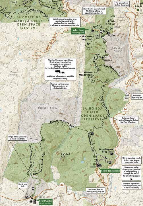
Grazing cows presented a bucolic scene. The ups and downs were relatively easy from 600 to 800 feet elevation. It was an out-and-back hike of about six miles. My second hike took me to the Allen Road entrance at the north end of the preserve. It required a permit that gave me solitude but no water, restrooms, maps, or guides. (Maps are now available.) I followed a broad shady trail to a small clearing where a narrow path took me about half a mile to what my map called “Big Tree.”
This 14-foot-diameter redwood was scarred and burned, but it had survived for hundreds of years. I walked back to the main trail, then turned left. A short walk brought me out of the forest into grassland where I saw an occupied residence and some old, deserted farm buildings. A small hill took me to a vista point with some nice views. It was a view worth a three-mile walk.
My next visit to the Sears Ranch Road entrance was special. On June 3, 2022, I was invited to the opening of the new Grasshopper Loop trail where we celebrated Midpeninsula Open Space’s 50th birthday, reaching 250 miles of public trail, and protecting 65,000 acres of greenbelt. We met Midpen’s general manager, board members, employees, volunteers, friends, and several dogs.
It was enjoyable, but the best part was walking the then-new 1.3-mile trail Grasshopper Loop. It offered minimal elevation gain on an easy walk through a varied landscape of grassland, oak woodlands, and redwood forest. Scenic views of distant hills were dotted with grazing cattle. A smooth dirt trail carried us through a forest with bigger trees.
I walked out of the shade and found a scenic viewpoint and a comfortable bench. This trail was easy, scenic, and with enough variety to keep it interesting. I recommend it for families and walkers of any age. In January, on Martin Luther King Junior’s birthday, I planned to see the new La Honda trails that connect the north and south entrances to a recently completed 17-mile trail network. I received my permit in just two working days, complete with a map, directions, and codes for access through a locked gate to a secure parking area.
Allen Road was narrow and slow, and it took some time to set the code number and open the lock. I did retrieve a map from the information board. My walk to the new trails started with a long downhill trek though forest followed by a long uphill in open country to Vista Point where I climbed to the top with only one rest stop. It was
worth the climb. The view was spectacular. The climb down the hill was easy, but the walk back up to my car climbed over 1,000 I was right about finding solitude. Throughout three hours of hiking, I saw only one family of three with dogs and one couple with a dog. (The couple loved the hike and appreciated being able to bring I walked a short distance on the Coho Vista Loop trail, but I’m saving the other three trails: the Lonely Forest, Western Meadowlark, and Lone Madrone for the The Lonely Forest Trail is a long walk that connects the new trails via the Harrington Creek Trail from the Sears Ranch Road entrance near Highway 84. It has single- track sections through groves of oak and bay trees. The trail is also shared by cattle. (Be sure to close the pedestrian gates.) The Western Meadowlark Trail wanders through second-growth redwood forest, ferns, sorrel, and spring flowers like Trillium, Pacific Starflower, and Woodland strawberry.
I’ve read that this trail is glorious. Western Meadowlark and Lone Madrone offer views of the historic Red Barn. You can also see the Red Barn while driving up Highway 84. Although the building is in the preserve, it is not open to the public.
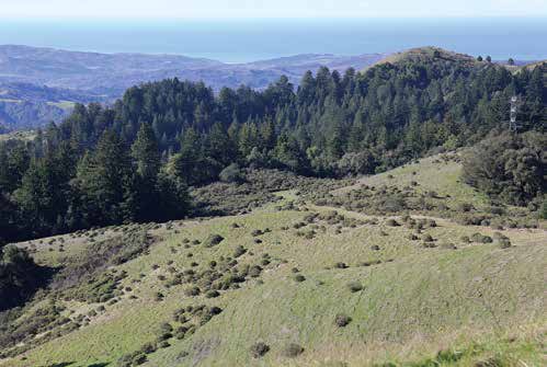
I am saving the Lone Madrone Trail for last. It has some very steep sections. It does, however, offer some great views of the Santa Cruz Mountains and the Pacific Ocean. If you have experience and good health, you can enjoy the preserve’s longer hikes.
Whether you hike, bike, or ride a horse, the trip involves traveling up to 14 miles with about 1,200 feet of elevation. South Skyline Association recommends setting aside three hours for your adventure. I would add that you should bring a map, water, good shoes, tissues, and a hat. A cellphone and software can be helpful but are not always The preserve is open to hikers on all trails.
Bikers, equestrians, and dogs are allowed on signed trails, but canine restrictions are If you are an inexperienced hiker or bringing a young family, I recommend the For an Allen Road permit, visit permits@ openspace.org or call 650-691-1200.
For more trail information, you can use an app that describes trail conditions in more detail. Google for Midpeninsula Trail Explorer. Directions. Take Highway 17 north toward Los Gatos. Exit on Alma Bridge Road and turn right to cross Highway 17.
Turn right on the frontage road and left on Black Road. Follow Black to Skyline. To Allen Street north preserve entrance: Take Skyline Blvd. past Highway 84 (Woodside Road). Turn left on Bear Gulch Road (2.3 miles north of Woodside Road).
Go 6/10 of a mile down Bear Gulch Road, then turn left on Allen Road. Drive 1.1 mile to the gate and follow permit instructions . To Sears Ranch south preserve entrance. Turn left on Highway 84 (Woodside Road). Pass the red barn and turn right on Sears